
In all the construction works today, underground surveying is very important. It requires surveying and locating subsurface features, hidden utilities, and structural elements that may affect the accuracy and safety of construction. The underground surveyor is to conduct a thorough inquiry of the subsurface to acquire accurate information useful to engineers and developers in their decision-making. The demand for accurate underground surveys is on the increase in the United Arab Emirates with mega infrastructure projects always being undertaken.
An Underground Surveyor’s Function
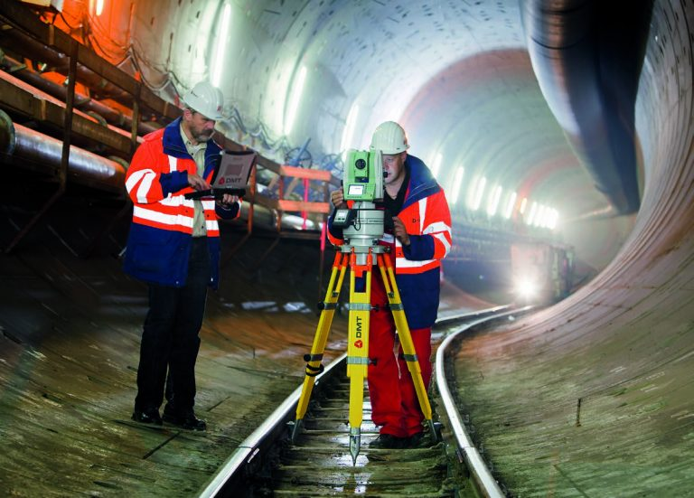
An underground surveyor specializes in locating and plotting hidden subsurface structures, including cables, pipelines, and subsurface building foundations. They apply state-of-the-art GIS technology and ground-penetrating tools to gather information that aids in ensuring compliance with safety regulations and the avoidance of potentially costly errors. Both pre-construction planning and the remodeling and enlargement of pre-existing structures depend on their services.
Improving Construction Precision With Accurate Mapping
Precise mapping is one of the main ways underground surveyors help ensure construction precision. They carry out comprehensive surveys to identify and designate subterranean utilities before any drilling or excavation starts. By ensuring that the construction team is fully aware of the subsurface layout, this procedure lowers the possibility of unintentional utility hits or incorrect calculations.
The alignment and placement of structural components are also enhanced by precise subterranean mapping. Accurate position information ensures that the project complies with design criteria by preventing misplacement during utility installation or foundation construction. The project’s overall stability and integrity are improved by this degree of accuracy.
Identifying Hidden Hazards to Reduce Risks
Underground surveyors find possible dangers below the surface, reducing risks. Underground surveys find hidden utility lines, abandoned infrastructure, and geological abnormalities in the United Arab Emirates, where infrastructure expansion encompasses both urban and desert areas. Early detection of these hidden challenges during the planning stage enables construction teams to make the required modifications.
Making Certain Regulatory Standards Are Followed
Construction work in the UAE is subject to stringent safety measures and requirements. Their surveys assist contractors in complying with legal and environmental requirements, confirming the location of utilities, property lines, and subsurface features.
Getting building permits frequently requires accurate documentation of subterranean surveys. Besides, it also protects developers from future conflicts or claims over subsurface dam-age by proof of due diligence.
Enhances Cost Effectiveness and Resource Efficiency
Through the work of underground surveyors, it removes guesswork from the work and exploratory digging, contributing to cost reduction in construction. Data driven perspectives enable project managers thus to plan with better avoidance of unnecessary excavation and consequent waste of materials.
Underground inspections can hamper damage to the existing utilities, thus preventing scarce and costly repairs and downtimes. Accurate identification of underground assets makes project scheduling much easier, which eliminates labor cost and delay.
Radar that penetrates the ground
One popular instrument for subterranean surveying is GPR. It produces fine-grained pictures of subterranean structures using radio waves. GPR is used by surveyors to find voids, hidden anomalies, and metallic and non-metallic items. The accuracy of building plans is increased by the technology’s capacity to deliver real-time data.
Locations Using Electromagnetics
Locating underground wires and pipelines requires the use of electromagnetic locators. These tools assist surveyors in pinpointing the precise position of subterranean utilities by identifying electromagnetic fields. This information eliminates inadvertent harm during excavation.
Laser Scanning in 3D
3D laser scanning offers incredibly detailed visual representations of subterranean features for larger projects. By providing accurate measurements and spatial data, this technology improves construction precision and project planning in general.
Improving Durability and Structural Stability
The stability and longevity of building projects are directly impacted by accurate subterranean surveys. Surveyors provide vital information about creating strong foundations by identifying various changes in soil composition, water levels, and load-bearing capacity.
Underground investigations are not only exceptional for developing construction techniques but also for materials in countries like the United Arab Emirates, where shifting sands and changing soil conditions do nothing but compromise a structure. This consideration has been of long-term durability because structures have been made with environmental situations in mind.
Supporting Urban Infrastructure Development
The importance of subterranean surveyors is growing as the United Arab Emirates keeps developing its urban infrastructure. Their efforts facilitate the precise and safe installation of commercial facilities, transportation networks, and utilities.
Underground surveys help organizations optimize space allocation during the development of major infrastructure projects such as residential complexes along with highways and metro lines. Accurate land use management in dense populations requires this high level of precision.
Minimizing Environmental Impact
Underground surveyors implement sustainable building practices through their work which minimizes environmental damage during excavation and development operations. Accurate mapping methods enable project sets to dig fewer holes resulting in protected natural environments and minimal soil interference.
During construction surveyors prevent contamination and ensure drainage management by discovering subterranean water resources along with drainage systems. The planned approach drives builders to implement sustainable construction techniques.
Improving the Timeliness and Efficiency of Projects
Construction works become faster and more efficient through accurate underground location services applied in projects. Through advanced investigations, surveyors generate certain information that lets contractors develop superior project schemes. Project schedules and resource distribution benefit from accurate planning when the project manager comprehends what lies beneath. Construction schedules shorten and projects finish in a reduced period.
Enhancing Security and Cutting Down on Liabilities
The construction industry relies on underground surveyors to protect workers through adequate safety measures since safety stands as their primary concern. Surveys made by these experts enable them to detect hazards like gas lines and unstable soil conditions which leads to accident prevention and safety for all personnel.
The utilization of precise subterranean mapping reduces the probability of experiencing third-party liabilities and corresponding claims. Construction businesses prevent critical legal expenses and payment compensation demands through successful utility strike prevention methods.
Conclusion
The UAE heavily relies on underground surveyors to enhance both the security measures and technological accuracy and performance of its construction work. Through precise mapping along with danger detection and regulatory compliance undergroundal survey in uae lead to project completion success. The developers obtain reliable information through their state-of-the-art surveying technologies which enables them to take well-informed decisions.
Professional underground surveyors will continue to be in high demand as the UAE’s infrastructure expands. Structures benefit from their work because it leads to greater durability and advances sustainable development coupled with improved construction accuracy.